This post is the second part of our interview with Kelly Rupp regarding the Shoreline Master Plan (SMP) update process in Pacific County. For more background, see the first post as well as our earlier intro to SMPs. And now we'll pick up right where we left off...
Q: How involved were the county commissioners?
A: Our Commissioners attended perhaps half the full-SMP meetings (monthly). Most importantly, they were briefed directly during three specific workshops during which key issues/changes/concerns were brought forward to ensure their understanding and gather their counsel. Overall, the Commissioners were on top of the entire process.
Q: How did your plan address sea level rise and coastal flooding?
A: A particular shoreline (the western shore of Willapa Bay) set its buffers for development based on Highest Astronomical Tide (HAT) as determined by NOAA. This particular geography is low-lying and subject to inconsistent tidal impacts (ie., storm surge combinations with King Tide conditions). By setting the buffer for development around an elevation (which NOAA adjusts annually, based on historical measures), an absolute/unequivocal/quantitative determination is achieved on setbacks, versus the more qualitative assessment of wetland plant delineations (used for OHWM boundaries).
Along the North Cove region in the County (also known infamously as Washaway Beach), the projected risk of coastal flooding prompted a specific moratorium on building and ongoing process for evaluation of future risk.
And concerns for protection of fresh-water aquifers in the Peninsula led to specific policy and regulation specifications regarding fill, grading, and site development.
Most significantly, the lessons from the 2011 Japanese Tsunami were foremost in our minds regarding coastal development risks. The need to protect the primary dunes facing the ocean to mitigate risks of flooding due to an earthquake/tsunami event led to very direct language on Dune Modifications and building setback in the relevant environmental designations.
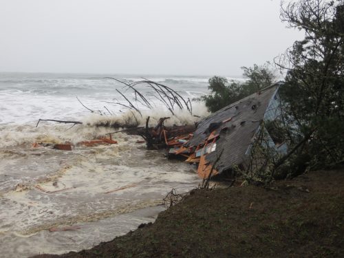
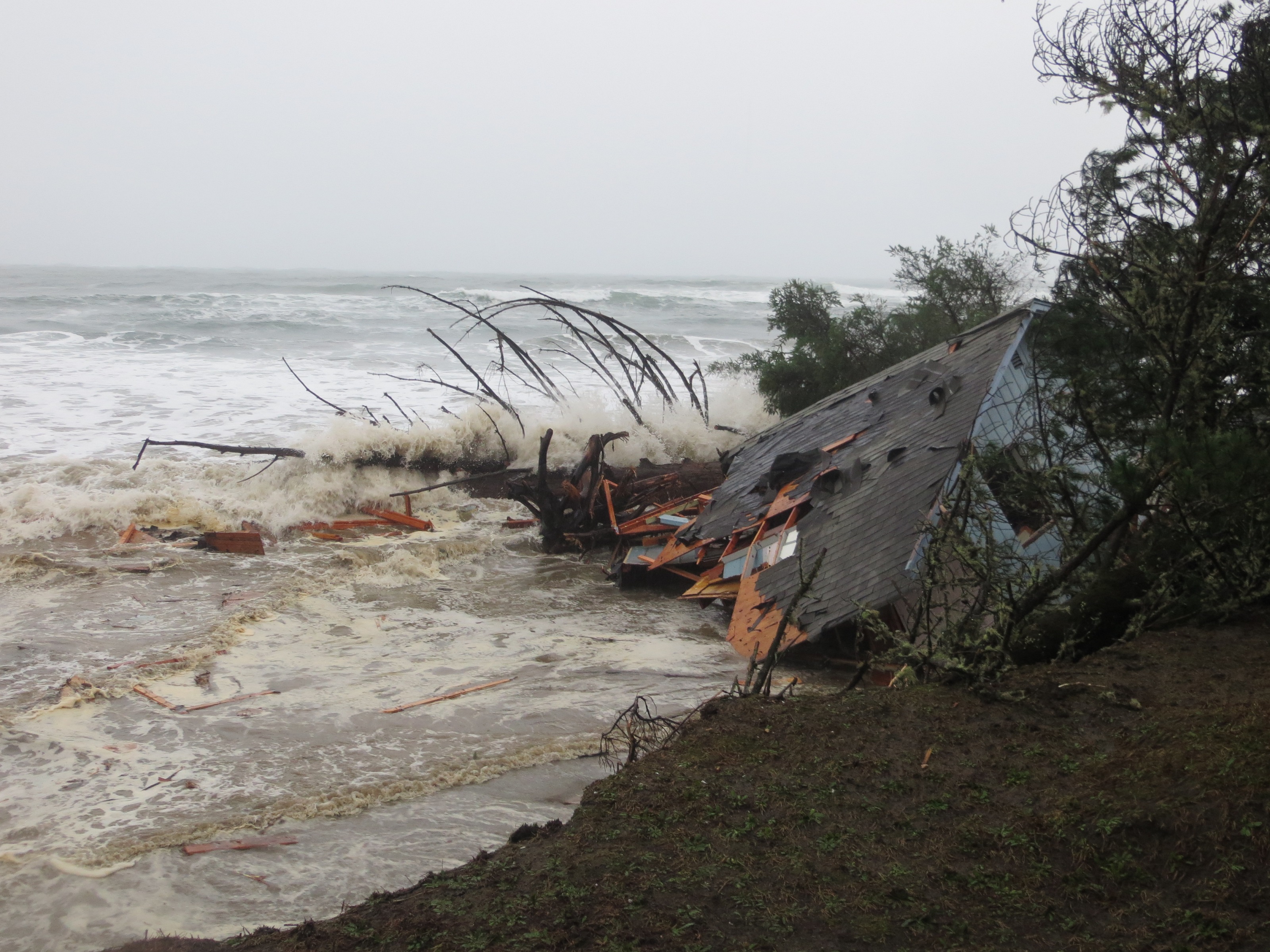 A house is swallowed by the ocean at Washaway Beach, more formally known as North Cove.
Q: What advice would you give to the folks involved in the next update?
A: Start early, with frequent articles in the newspaper and informative public meetings, to acquaint individuals with the process and expectations. Gather key issues early on, and enlist engaged/vocal participants on the committee (and subcommittees) who recognize their personal responsibility to represent one or more constituencies (environmental, agency, industry, development, etc).
Also important (crucial) is understanding who/what/how Ecology (the ultimate approver) will want to see and accept. And keep Ecology closely apprised of the deliberations throughout the entire process.
Q: If you could change any guidelines or requirements, which ones would those be?
A: Because Pacific County borders on the Columbia River and Pacific Ocean, ecological impact from events/situations outside of the county’s jurisdiction empowered by the SMA (Shoreline Management Act) could have devastating consequences (eg., oil spill up the Columbia River, natural gas or other toxic chemical releases from shipping accidents coming into/out of the Columbia). The SMA gives the county no room to even declare such potential concerns as relevant to its obligation to ensure “No Net Loss” in ecological function along its shorelines. Amendment to the SMA would be advised, or at least a provision added to Ecology guidelines to allow county responses or consideration of such “out of jurisdiction” origination impacts.
Additionally, additional direction on sea level rise and climate change should be included/required. Current guidelines do not sufficiently direct the county to be as comprehensive as we (on the coast) believe necessary.
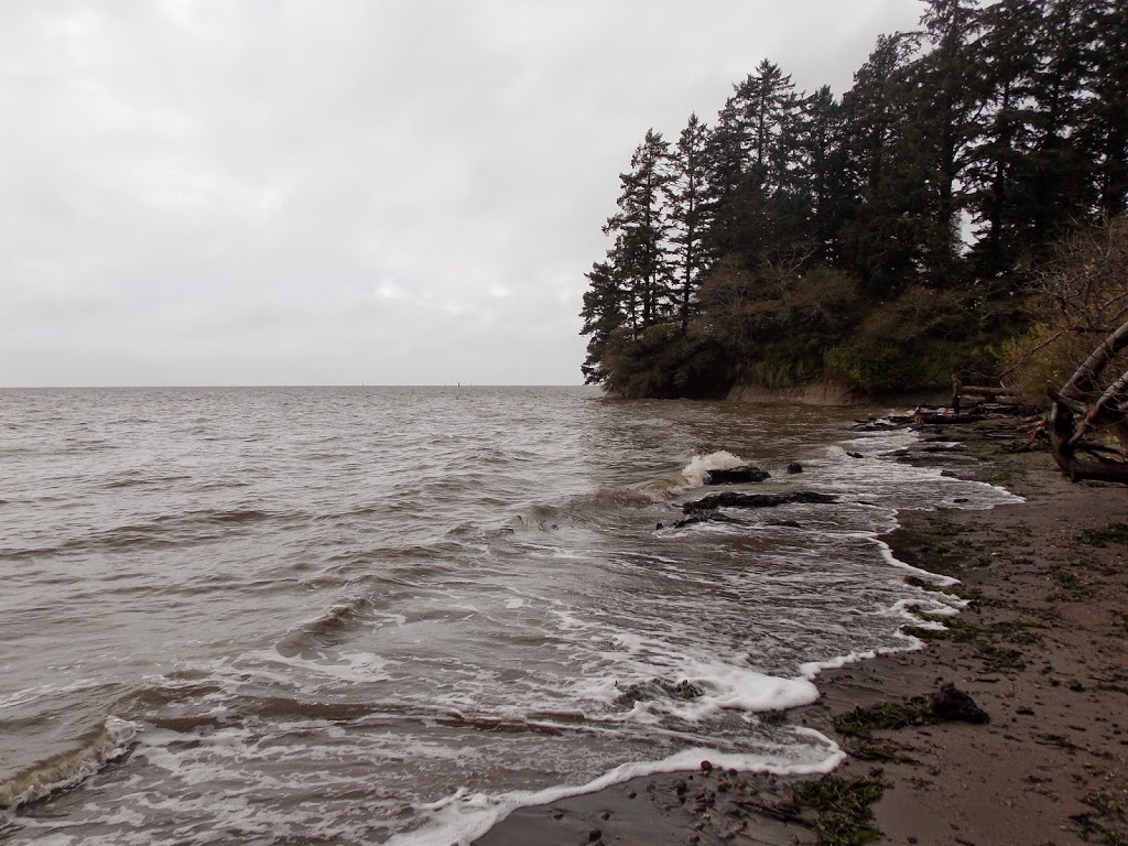 A small beach surrounded by bluffs in Pacific County that will see increased inundation and erosion from future Sea Level Rise.
Q: Do you think the plan is strong enough to protect the shorelines from losing their ecological functions in the long term?
A: No. The plan directs the county to emphasize human-caused development or impact, and fails to address broader-than-county and natural changes in the environment which probably (in Pacific County’s case) are far more significant to the long-term “No Net Loss” imperative of the SMA.
Also, insufficient enforcement of the plan will be a concern (due primarily to lack of county administrative personnel and a lack of willingness to enforce regulations).
Q: Do you think the plan is strong enough to protect newly developed public and private property from infrastructure loss due to coastal flooding and predicted sea level rise?
A: To a large extent (geographically), yes. The use of HAT along the Willapa shoreline, the specific protections for dunes facing the ocean, the concerns expressed over building along coastal erosion zones, etc all consider long-term events of sea level rise and climate-change-induced severe storm events.
Stronger development guidelines for tsunami-risk zones are needed, however, as the SMP is only directed to consider “likely” events and not extraordinary or cataclysmic impacts.
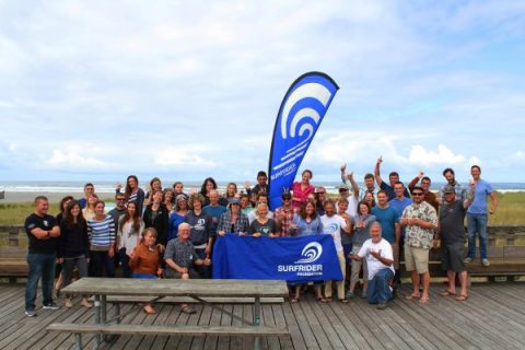 Surfrider chapter leaders and staff enjoying their visit to Long Beach for the 2015 Cascadia Chapter Conference.
Q: Based on the new SMP, what will the shorelines of Pacific County look like in 20 years? What about 100 years from now?
A: Barring extreme seismic and tsunami events, but expecting regularly-severe winter storms, we expect to see more and more headland erosion, particularly west-facing lands. The North Cove area itself is likely to erode dramatically further to the north, likely meaning that Highway 105 will require substantive reinforcement in order to continue in its current grade (i.e., Highway 105 is likely to define the northern shoreline of Willapa Bay, in this scenario). Existing rivers and streams will exact continued erosion (natural). Of course, a dramatic storm event or tsunami changes all projections.
Sea level rise can be expected – certainly in 100 years – to dramatically change what “waterfront development” means along Willapa Bay shorelines. Many home sites now approved for development will be underwater, and septic systems throughout the Peninsula will be compromised without amendment. Awareness of impending changes is high, however, regardless of SMP regulations; it is expected that more and more individuals seeking to build along the coast will include provisions in their building designs to anticipate these changes.
Development pressures in the county are thankfully not as significant as in more populated areas, such that natural evolution of topography and vegetation is likely to occur.
Of greatest concern is out-of-jurisdiction impacts: invasive species, ocean acidification, a toxic chemical spill, etc. The impact of these threats to our “No Net Loss” directive cannot be overstated, and the SMP is weakly equipped to address these concerns (or even to express these concerns fully).